Locations
Flaman Rentals Blog
RSS feed
Categories
Recent activity
- What's it like being a Flaman Rental Dealer?
- A Brief History of the Newest Flaman Store in Swift Current
- Disney's NEW Leadership Excellence Training Course
- Disney's Approach To Quality Service
- Disney's Approach To Quality Service
- Trailering 'Rules of the Road' Updated
- 10th Annual Frank J. Flaman Foundation Gala 2016
- Why Frank Cares
Authors
Archive
NDVI Drones
Posted by Jonathan Hutchinson May 30, 2017
Aerial imaging can be used as a good indicator of crop health. The emergence of drone technology makes this process more affordable, and accessible. A drone accompanied with a remote sensor, and the NDVI graphical indicator, is all you need to gain useful information on the health of your crop.
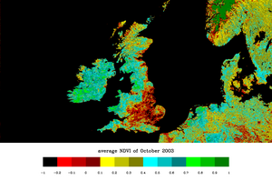
The normalized difference vegetation index (NDVI) is a simple graphical indicator that can be used to analyze remote sensing measurements, typically but not necessarily from a space platform, and assess whether the target being observed contains live green vegetation or not.
NDVI was one of the most successful of many attempts to simply and quickly identify vegetated areas and their "condition," and it remains the most well-known and used index to detect live green plant canopies in multi-spectral remote sensing data. Once the feasibility to detect vegetation had been demonstrated, users tended to also use the NDVI to quantify the photosynthetic capacity of plant canopies.
The basic principle of NDVI relies on the fact that, due to the spongy layers found on their backsides, leaves reflect a lot of light in the near infrared, in stark contrast with most non-plant objects. When the plant becomes dehydrated or stressed, the spongy layer collapses and the leaves reflect less NIR light, but the same amount in the visible range. Thus, mathematically combining these two signals can help differentiate plant from non-plant and healthy plant from sickly plant.
Posted in Farm related news | Tagged with drones ndvi aerial imaging crop health remote sensor | More articles by Jonathan Hutchinson
Website © Flaman Group of Companies 2000-2026